 Image 1 of 1
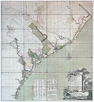
William Gerard De Brahm's Map of South Carolina and a Part of Georgia is one of the most influential maps of early southeastern North America. Described by historian Mart A. Stewart as "one of the maps that has gained a reputation as the first 'scientific' or 'modern' map" of the region, de Brahm's map became "the standard source for geographic knowledge of the area at its time" (Mart A. Stewart, "William Gerard de Brahm's 1757 Map of South Carolina and Georgia," 524).
De Brahm's 1757 map focuses on the Atlantic coastlines of colonial South Carolina and Georgia, containing "all the Islands, Inlets, Rivers, Creeks, Parishes, Townships, Boroughs, Roads, and Bridges," as well as "Several Plantations, with their proper Boundary Lines, their Names, and the Names of their Proprietors."
Made with 300 gsm (110 Cover) Canaletto (20% cotton/80% virgin cellulose